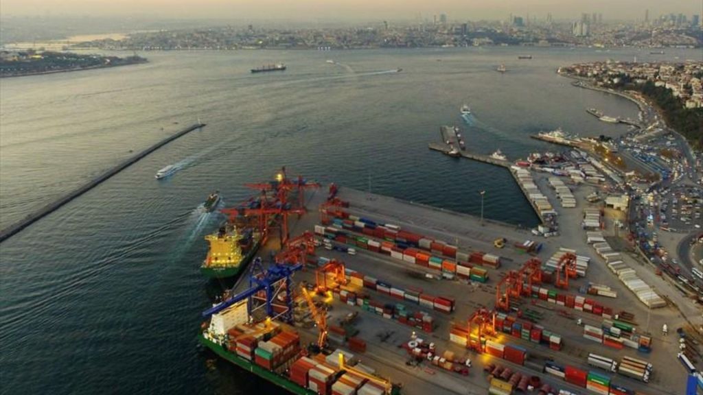
Port of Istanbul
UN/LOCODE: TRIST
Latitude: 41.0277° N
Longitude: 28.9739° E
Size: The Port of Istanbul spans over 1500 acres.
Cargo Handling: It has a total cargo handling capacity of over 3 million TEUs (Twenty-foot Equivalent Units) annually.
Other Information: The Port of Istanbul has multiple terminals, including Ambarli, Haydarpasa, Marport, and Kumport, each specializing in various types of cargo, including containers, general cargo, and bulk cargo.
History of the Port of Istanbul
The Port of Istanbul, originally established as Byzantium around 660 BC, has been a key maritime hub through various historical periods. Under Roman Emperor Constantine the Great, it became Constantinople and thrived as a crucial trade and naval center. The Ottomans, who conquered the city in 1453, further enhanced the port’s prominence with significant infrastructure developments. In the modern era, the port underwent extensive modernization to meet the demands of global trade, solidifying its role as one of the busiest and most important ports in the region.
The Gateway to Two Continents
The Port of Istanbul is in a special place in Turkey’s maritime sector because it is at the meeting point of Europe and Asia. It boasts a rich history dating back to ancient times when it served as a hub for the Byzantine and Ottoman empires. Today, it continues to be a vital player in global trade, connecting Eastern and Western markets.
The Port of Istanbul serves as a major entry and exit point for various cargo types, including containers, bulk cargo, and petroleum products. Its strategic location along the Bosphorus Strait makes it an ideal choice for vessels transiting between the Black Sea and the Mediterranean.
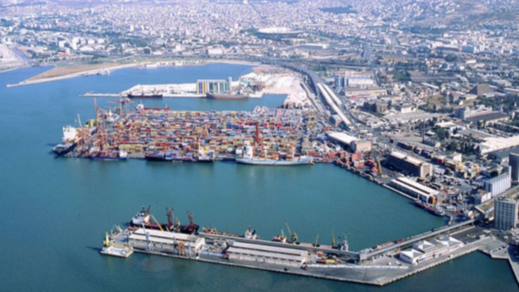
Port of Izmir
UN/LOCODE: TRIZM
Latitude: 38.4237° N
Longitude: 27.1428° E
Size: The Port of Izmir covers an area of approximately 1,200 acres.
Cargo Handling: Over 1.5 million TEUs of cargo can be handled there every year, and it can handle different kinds of cargo, such as containers, general cargo, and Ro-Ro activities.
Other Information: Izmir’s port facilities are well-connected to industrial zones in the region, enhancing its role in the Turkish economy.
History of the Port of Izmir
The Port of Izmir, situated on Turkey’s Aegean coast, has been a significant maritime center since antiquity. In the past, the port, which was called Smyrna, was an important place for trade and cultural exchange because of its position. During the Roman and Byzantine periods, Smyrna flourished as a prominent commercial and naval port. The Ottomans, who took control in the 15th century, modernized the port to boost trade and military strength. In the late 19th and early 20th centuries, significant expansions and infrastructure improvements transformed it into a modern, bustling port. Today, the Port of Izmir continues to be a key player in Turkey’s trade and economic activities, reflecting its long history of maritime significance.
Aegean Gateway
Moving south along the Turkish coastline, we arrive at the Port of Izmir. Located on the Aegean Sea, this port is a key access point to the bustling Aegean region. Its significance lies in its ability to support various industries, including automotive, textiles, and chemicals.
The Port of Izmir has modern facilities that handle containers, general cargo, and Ro-Ro (roll-on/roll-off) operations efficiently. Its proximity to major industrial zones in Turkey enhances its importance in the country’s economy.
Port of Mersin

UN/LOCODE: TRMER
Latitude: 36.8460° N
Longitude: 34.6227° E
Size: The Port of Mersin is spread across more than 700 acres.
Cargo Handling: It handles a wide range of cargo types, with an annual capacity of over 4 million TEUs.
Other Information: Mersin serves as a key gateway for trade with the Middle East, making it a pivotal port for Turkey’s import and export activities.
History of the Port of Mersin
The Port of Mersin, located on Turkey’s southeastern Mediterranean coast, has been an important maritime gateway since antiquity. Known in ancient times as Zephyrium, the port’s strategic location facilitated trade between Anatolia and the Middle East. During the Roman and Byzantine periods, it served as a key commercial and naval point. The Ottomans recognized its potential in the 19th century and invested in expanding the port’s facilities. Major developments in the late 20th and early 21st centuries have transformed Mersin into a modern, bustling port, crucial for Turkey’s trade with international markets. Today, it remains a vital economic and logistical hub in the region.
Linking Turkey to the Middle East
Venturing to the southern coast, we encounter the Port of Mersin. Positioned on the Mediterranean Sea, this port plays a crucial role in facilitating trade between Turkey and the Middle East. Its location offers a competitive advantage in connecting Turkish products to the broader Arab world.
The Port of Mersin boasts state-of-the-art infrastructure, capable of handling various cargo types. It’s a key player in the import and export of goods like agricultural products, machinery, and chemicals.
Port of Antalya

UN/LOCODE: TRAYT
Latitude: 36.8992° N
Longitude: 30.6804° E
Size: Antalya’s port area covers approximately 120 acres.
Cargo Handling: While it mainly caters to tourism and cruise ships, the port is gradually expanding its capacity for regional trade.
Other Information: Antalya’s scenic location and tourism industry contribute to its unique role as both a trade and leisure destination.
History of the Port of Antalya
The Port of Antalya, situated on Turkey’s southwestern coast, has been a significant maritime location since ancient times. In ancient times, the port was called Attaleia. It was built by the Roman Emperor Hadrian in the second century AD and was a major center for trade and the navy during the Roman and Byzantine periods. In the Ottoman period, Antalya continued to function as a key port for regional trade. The modern era saw significant development, with improvements in infrastructure and expansion of facilities. Today, the Port of Antalya is a crucial gateway for tourism and trade, reflecting its enduring importance throughout history.
Where Tourism Meets Trade
Antalya, known for its stunning coastal beauty, is also home to the Port of Antalya. While it primarily serves the thriving tourism industry, this port has been expanding its role in regional trade. Cruise ships often dock here, bringing thousands of tourists to the region.
Turkey is becoming more and more popular as a tourist spot, and the Port of Antalya is very important to the tourism business. Moreover, its potential for facilitating trade is on the rise, thanks to ongoing infrastructure improvements.
Port of Iskenderun

UN/LOCODE: TRISK
Latitude: 36.5876° N
Longitude: 36.1606° E
Size: The Port of Iskenderun encompasses around 400 acres.
Cargo Handling: It specializes in handling energy-related cargo, including oil, natural gas, and coal, with a total capacity exceeding 12 million tons annually.
Other Information: Iskenderun’s role in the energy sector is crucial for Turkey’s energy supply chain.
History of the Port of Iskenderun
The Port of Iskenderun is on the southern coast of Turkey, near the Mediterranean Sea. It has a long past that goes back to ancient times. Originally known as Alexandretta, the port was founded by Alexander the Great in the 4th century BC to serve as a vital trade link between the Mediterranean and the interior of Anatolia. Throughout the Roman and Byzantine periods, Iskenderun was an important commercial and naval center. The Ottomans recognized its strategic value in the 16th century and enhanced its facilities. In the 20th century, significant modernization and expansion efforts transformed it into a key port for trade and industry. Today, Iskenderun remains a major economic hub in the region, crucial for Turkey’s maritime activities.
Energy and Beyond
Moving east along the Mediterranean coast, we reach the Port of Iskenderun. This port is of paramount importance for Turkey’s energy sector, as it handles a significant portion of the country’s energy imports and exports. Iskenderun plays a crucial role in supplying energy resources to power the nation.
In addition to its work in the energy field, the Port of Iskenderun also helps other industries, like agriculture, steel, and cars. Its continuous development is essential for Turkey’s economic growth.
Port of Gemlik

UN/LOCODE: TRGEM
Latitude: 40.4310° N
Longitude: 29.1915° E
Size: Gemlik port area covers approximately 200 acres.
Cargo Handling: It handles various cargo types, including containers and bulk cargo, with an annual capacity exceeding 500,000 TEUs.
Other Information: Gemlik’s strategic location on the Sea of Marmara facilitates efficient transportation to Istanbul and surrounding regions.
History of the Port of Gemlik
The Port of Gemlik, located on Turkey’s northwestern coast of the Sea of Marmara, has been an important maritime location since ancient times. Known historically as Myrleia, the port’s strategic position facilitated trade between Anatolia and the Balkans. During the Roman and Byzantine periods, it served as a significant commercial hub. The Ottomans further developed the port in the 19th century, enhancing its infrastructure to support increasing trade and military needs. In the 20th century, modernization efforts improved its facilities and capabilities. Today, the Port of Gemlik remains a key player in Turkey’s maritime trade, reflecting its historical importance and continued relevance in regional commerce.
Versatility at its Best
The Port of Gemlik, situated on the Sea of Marmara, is known for its versatility in handling various types of cargo. From containers to bulk cargo, it efficiently manages the flow of goods, making it an integral part of Turkey’s logistics network.
Geographically, Gemlik’s location provides easy access to Istanbul and the industrial heartland of Turkey. This proximity enhances its value in connecting markets domestically and internationally.
Port of Samsun

UN/LOCODE: TRSAH
Latitude: 41.2887° N
Longitude: 36.3300° E
Size: The Port of Samsun covers an area of around 180 acres.
Cargo Handling: It plays a significant role in connecting Turkey to the Black Sea region, handling various cargo types, including general cargo and bulk cargo.
Other Information: Recent infrastructure developments are expected to bolster Samsun’s position as a key trade gateway in the Black Sea.
History of the Port of Samsun
The Port of Samsun, located on Turkey’s northern Black Sea coast, has been a crucial maritime center since ancient times. Known in antiquity as Amisos, it was a significant trade and naval hub for the region. During the Roman and Byzantine periods, Samsun played a key role in regional commerce. The Ottomans further developed the port in the 19th century, recognizing its strategic importance for trade and military purposes. In the 20th century, extensive modernization and expansion efforts transformed Samsun into a modern port facility. Today, the Port of Samsun continues to be a vital economic and logistical hub, supporting Turkey’s trade with Black Sea and international markets.
Gateway to the Black Sea
Our journey concludes in the north, at the Port of Samsun. Positioned on the Black Sea coast, Samsun has historical significance as a key trade gateway. While it may not be as large as some other Turkish ports, it plays a crucial role in connecting Turkey to the Black Sea region and beyond.
Recent developments in Samsun’s infrastructure have positioned it as a potential growth hub for various industries. Its strategic location makes it an attractive option for companies looking to expand their presence in the Black Sea region.
Turkey’s seven major ports each offer a unique set of advantages, contributing to the country’s prominence in global maritime trade. These ports, strategically located across the Turkish coastline, serve as vital conduits for goods, connecting Turkey to the world and fostering economic growth. As Turkey keeps putting money into its maritime infrastructure, these ports will become even more important. This will strengthen Turkey’s place as a major player in the global maritime industry.