Introduction to the Geirangerfjord
Location and geography
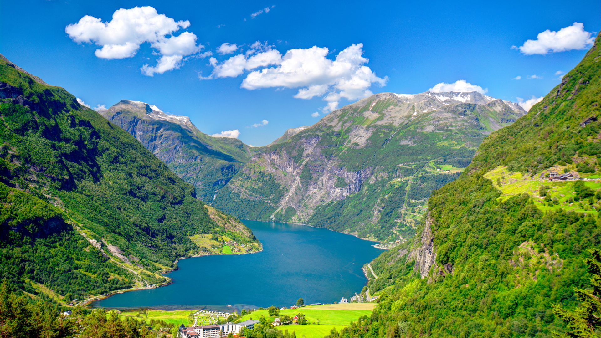
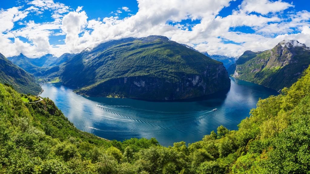
Tucked between the Norwegian towns of Ålesund and Trondheim, the Geirangerfjord stretches inland from the Storfjorden for over 15 kilometers, branching into equally stunning tributary fjords. The main fjord is relatively narrow, at some points only half a mile wide yet over 1,300 feet deep. Sheer rocky outcrops, several over 4,000 feet tall, flank the crystalline waters through the length of the fjord, drained by hundreds of waterfalls dotted across the cliffs.
History and significance
As one of Norway’s most visually stunning locales, the Geirangerfjord has drawn visitors since the 19th century. Early tourists arrived by steamer ships while modern travelers flock by automobile, cruise liner, and sightseeing boats. The fjord landscape strongly represents Norwegian cultural identity, signified by its inscription as a UNESCO World Heritage site. Ongoing preservation efforts aim to protect the natural majesty and heritage for future generations.
Unique geography of the fjord landscape
Formation of fjords over time
The distinctive long, narrow shape of fjords originates from past glacial activity over ice ages. Movement of vast ice sheets flowing down valleys gouged out basins near the coast which later flooded with sea water as the glaciers retreated. The Geirangerfjord displays the classic deep U-shaped cross section caused by this forceful glacial erosion.
Characteristics of fjord terrain
Fjords display unique geographic traits sculpted by their formations. Steep rocky slopes plunge directly into the sea, since previous glacial carving removed less resistant shoreline sediments. Tributary gulleys known as hanging valleys often hold breathtaking waterfalls created by meltwater cutting new paths down the sheer cliffs. The mountains surrounding the Geirangerfjord exhibit these typical fjord features in remarkable vertical relief.
Steep cliff sides
Nearly vertical rock walls rise from all sides of the Geirangerfjord, including the iconic Seven Sisters falls. The narrow fjord reaches depths over 1300 feet, demonstrating the power of moving ice to scour the land surface.
Narrow inlets
Inlets branch from the main fjord, bordered by the same towering rocky relief drained by hanging valley waterfalls. These offshoots exhibit similar deep, steep-walled geographic profiles on a reduced scale.
U-shaped valley
A cross-section of the landscape reveals a classic U-shaped valley molded by the fjord. This distinct form emerges from glacial erosion scraping a rounded channel versus the V-shaped valleys carved by running water alone.
Climate and environment
Precipitation patterns
Situated near the Gulf Stream, the area exhibits higher rainfall relative to other Scandinavian regions. Abundant winter snow accumulates at higher elevations while peaks remain glacier-covered year round. Numerous waterfalls cascade from this moisture cycling through the mountains down the fjord sides.
Flora and fauna found in the region
Despite colder conditions at altitude, the warming ocean influence enables rich montane vegetation and wildlife. Birch forests mixed with willow and rowan climb the lower slopes with alpine meadows nearer ridgelines. The cold clear waters host marine ecosystems and migratory fish runs critical for native species survival.
The village of Geiranger
Origins and development
People have inhabited the head of the fjord for centuries focused on fishing, trapping, and small homesteads. The village site allowed sheltered access to coastal trade routes for isolated inland residents. Today just over 200 permanent residents live year-round in Geiranger village.
Traditional architecture and way of life
Early residents constructed wooden farm buildings well-suited to cold winters and the difficult terrain. Steeply pitched roofs allow heavy snows to easily slide off while minimal windows reduced heat loss. Settlement patterns followed the shoreline rather than climbing hillsides to simplify transport. Fishing and shepherding drove the traditional village economy and culture.
Tourism and activities

Cruise ships and tours
Large sightseeing vessels have sailed the Geirangerfjord for over a century. Contemporary cruise liners still call regularly, anchors down in the harbor with launches shuttling passengers ashore to explore. Smaller tour boats and sea kayak rentals provide alternative fjord explorations.
Hiking trails
Myriad hiking routes thread along the fjord ranging from gentle lakeside paths to challenging mountain summit scrambles. Trails access cascading waterfalls and offer panoramic vistas over this signature Norwegian landscape for savvy outdoor enthusiasts.
Kayaking/boating
Sea kayaking adventures appeal to athletic visitors seeking intimacy with the environment. Spectacular scenery surrounds paddlers gliding silently across the placid waters towards towering waterfall backdrops. Recreational power boats zip sportsmen to fish teeming runs entering the fjord.
Cultural impacts
Folk music tradition
The Geiranger region culturally identifies with a music style known as stev, a traditional Norwegian singing practice passed through generations. Vocal lyrics and themes strongly represent the rural villagers’ deep connections to nature and community.
Cuisine featuring local delicacies
Local dining focuses on ingredients from land and sea. Smoked or pickled fish, game meats, foraged edible plants, cloudberries, and wild herbs create a distinct regional Norwegian culinary tradition.Restaurants in Geiranger village showcase these hyperlocal flavors for guests.
Preservation efforts
Limiting development
Norwegian oversight intensely protects the natural heritage of the Geirangerfjord region. Building restrictions concentrate hotels, shops, and housing in Geiranger village prohibiting expansion along the vulnerable fjord. This policy intends to balance tourist infrastructure needs with minimizing environmental impact.
Regulating cruise traffic
Boat and cruise traffic now face stricter regulation to improve sustainability. Scheduled coordinated arrival systems aim to reduce congestion through Norway’s iconic fjord corridors. Future quotas may further decrease large vessel tourism on the Geirangerfjord if environmental pressures continue mounting.
Related UNESCO sites
Nearby Nærøyfjord
The Nærøyfjord branches from the main Sognefjord within 50 miles of Geirangerfjord, distinguished as an equally spectacular complementary UNESCO site. Nærøyfjord cuts an exquisite course through towering mountains with powerful waterfalls plunging from hanging valleys along its length.
Struve Geodetic Arc
This surveyor’s system of triangulation points arcs across 10 countries including a Norway point above Geirangerfjord. The precisely mapped locations enabled accurate 19th century scientific measurement linking Black and Caspian Seas, earning its own UNESCO World Heritage inscription.
Transportation to access Geirangerfjord
Roads and tunnels
Overland travelers journey along Highway 63 showcasing scenic mountain vistas down to the waters far below. A series of 11 hairpin highway switchbacks climbs steeply onto the Dalsnibba Plateau delivering an ultimate birds-eye panorama over Geirangerfjord framed by mountains and glaciers.
Ferries and boat transit
A car ferry across the fjord connects Geiranger village to Hellesylt providing alternative regional access from summit to sea. Smaller passenger ferries run tourists between settlements along the fjord corridor not connected by roads in this challenging cliff-lined terrain.

Future outlook
Balancing tourism and sustainability
Preserving such a culturally significant natural wonder presents complex challenges between celebrating heritage and safeguarding fragile environments. Norway leads progressive efforts managing visitor impacts but the future remains uncertain as global climate shifts and tourism expands. Ongoing stakeholder collaboration strives to sustain Geirangerfjord for posterity.
Continuing as a Norwegian icon
This majestic fjord landscape indelibly represents the heritage of Norway with its breathtaking terrain and cultural traditions. Strategic conservation policies aim to uphold Geirangerfjord as an unspoiled emblem of this Nordic country through shifting times ahead. Balancing admiring visitors with ecological stability will enable its wilderness splendor and tiny charming villages to persist as icons into Norway’s future.