
Erie Canal

The Erie Canal, often referred to as the “Nation’s first Superhighway,” is undoubtedly one of the most famous canals in the United States. This 363-mile-long canal, which was finished in 1825, went from the Hudson River to Lake Erie. It made a straight connection between the Atlantic Ocean and the Great Lakes region. By lowering shipping costs and making it easier to move people and goods, the Erie Canal was a key part of making the Midwest a place where people could live and the economy to grow.
Initially, the Erie Canal was 12 meters wide and 1.2 meters deep, but it underwent several expansions to accommodate larger ships. It operated at its peak capacity in the 1850s, with approximately 33,000 commercial shipments passing through annually. The canal remained competitive with railroads until 1902 when rail transportation began to surpass canals in speed and convenience. Today, the Erie Canal is primarily used for recreational purposes and has become a popular tourist attraction, with parks and museums dedicated to its rich history.
Panama Canal
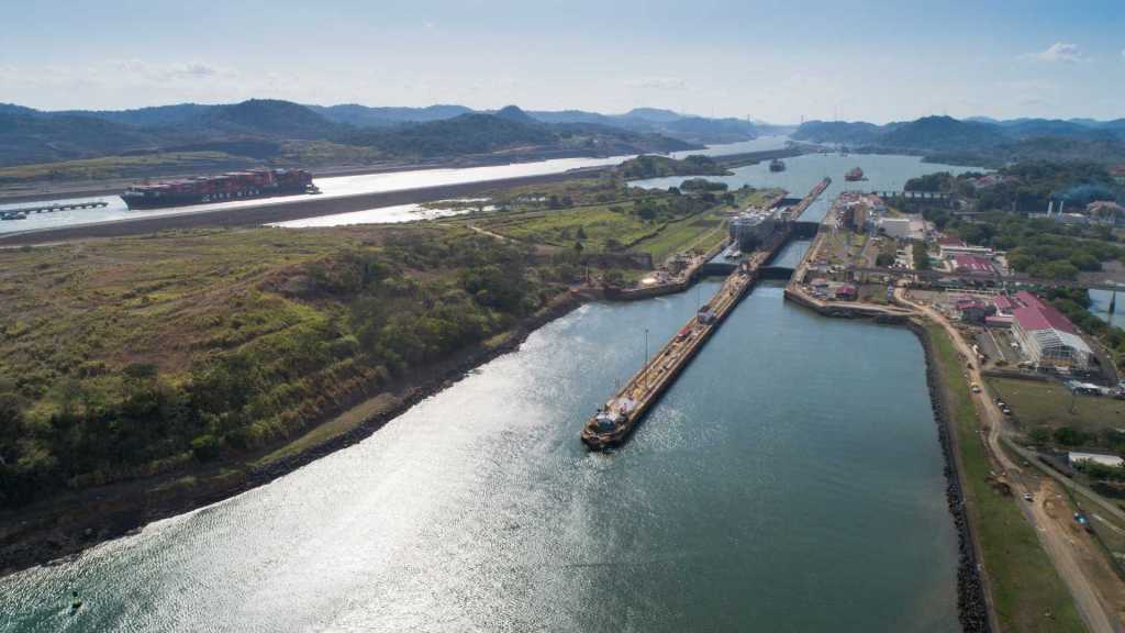
Although not located within the United States, the Panama Canal deserves mention due to its historical significance and impact on international trade. This 51-mile canal, connecting the Atlantic and Pacific Oceans, was constructed by the United States and completed in 1914. It lets ships avoid the dangerous route around the southern tip of South America called Cape Horn. Ships that go from the east coast to the west coast of the US save a lot of time and money this way.
The Panama Canal was an engineering feat. A channel had to be dug through thick tropical rainforests, and a system of locks was set up so that ships could be raised and lowered to different water levels. The canal has since become a vital international trade route, handling millions of tons of cargo each year. Its strategic location has transformed global shipping and has had a profound impact on the economies of the countries it connects.
Chesapeake and Ohio Canal

You can find the famous Chesapeake and Ohio Canal, or C&O Canal, 184.5 miles long, running from Washington, D.C., to Cumberland, Maryland. The canal’s building began in 1828 and was finished in 1850. The main reason the C&O Canal was built was to move coal from the Allegheny Mountains to eastern U.S. markets.
The canal was very important to the economic growth of the area because it made moving goods and raw materials safe and easy. It operated for over 90 years before declining competition from railroads led to its closure in 1924. Today, the Chesapeake and Ohio Canal National Historical Park protects what’s left of the canal and lets people enjoy nature by hiking, biking, and swimming.
Illinois and Michigan Canal

The Illinois and Michigan Canal, sometimes written as “I&M Canal,” was a major waterway that linked the Mississippi River to the Great Lakes. The canal’s building began in 1836 and was finished in 1848. This 96-mile canal played a pivotal role in the development of the Midwest by providing a route for transporting goods and people between the eastern United States and the expanding western territories.
The I&M Canal facilitated the movement of agricultural products, manufactured goods, and natural resources, contributing to the growth of cities such as Chicago. As railways became more prominent, the canal gradually lost its importance and was officially closed in 1933. On the Illinois and Michigan Canal State Trail, people can learn about the famous canal and enjoy outdoor activities like hiking and biking.
Welland Canal

The Welland Canal, located in Ontario, Canada, but integral to the transportation network of the Great Lakes region, is a series of canals and locks that allow ships to bypass the Niagara Falls and navigate between Lake Ontario and Lake Erie. The first Welland Canal was finished in 1829. The current canal system is the result of additions and changes made over the years.
A vital link between the Great Lakes and the St. Lawrence Seaway, the Welland Canal allows ships to reach ports in both Canada and the US. It is a vital trade route, accommodating vessels carrying a wide range of cargo, including bulk commodities, containerized goods, and even recreational boats. The St. Lawrence Seaway Management Corporation operates the canal, which is crucial for international trade and shipping.
Chesapeake and Delaware Canal
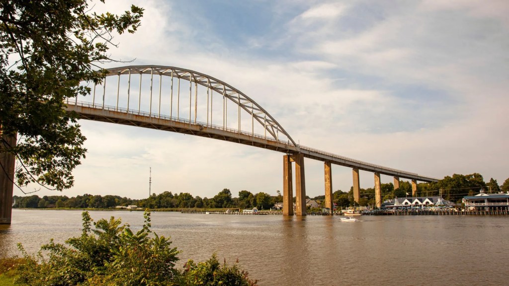
A fourteen-mile waterway that links the Delaware River to Chesapeake Bay, it is formally called the Chesapeake and Delaware Canal (C&D Canal). The canal was completed in 1829 and has since provided a more direct route for vessels traveling between the two waterways, bypassing the longer and more treacherous journey around the Delmarva Peninsula.
The C&D Canal is an important transportation corridor, allowing ships to access major ports along the Eastern Seaboard and facilitating the movement of goods and commodities. It is operated and maintained by the U.S. Army Corps of Engineers and plays a vital role in regional and international trade.
Cape Cod Canal

Connecting Buzzards Bay in the south and Cape Cod Bay in the north, the Cape Cod Canal spans the Massachusetts coast along the southern tip of Cape Cod. The canal was completed in 1916, creating a shortcut for vessels traveling between the Atlantic Ocean and the ports of Boston and New York.
The Cape Cod Canal is approximately 7 miles long and has a significant impact on maritime transportation in the region. Under its supervision, the United States Army Corps of Engineers constructs a waterway that ships can use to circumvent Cape Cod, a safer and more direct route. Many people enjoy fishing and sailing on the canal for fun.
Gulf Intracoastal Waterway
The Gulf Intracoastal Waterway, also known as the GIWW, is an inland waterway that stretches along the Gulf Coast of the United States, connecting Texas, Louisiana, Mississippi, Alabama, and Florida. The waterway extends for approximately 1,300 miles and provides a navigable route for commercial vessels, recreational boats, and barges.
Facilitating the transit of products and commodities between inland sites and ports on the Gulf Coast, the GIWW acts as an essential transportation corridor. It provides an alternative to shipping along the open seas, offering a sheltered and more efficient route for vessels. The Gulf Intracoastal Waterway is maintained by the U.S. Army Corps of Engineers and plays a crucial role in the Gulf Coast’s economy and trade.
Ohio River
The Ohio River, although not a traditional canal, serves as a significant inland waterway that spans approximately 981 miles, flowing through or along the borders of six states: Illinois, Indiana, Kentucky, Ohio, Pennsylvania, and West Virginia. The Ohio River has historically been a vital transportation artery, connecting the Midwest to the Mississippi River and ultimately the Gulf of Mexico.
The Ohio River has been very important to the growth of trade and business in the area. It has facilitated the transportation of goods such as coal, iron, and agricultural products. While not a man-made canal, the Ohio River’s importance to waterborne transportation cannot be overstated.
Canals have been very important to the growth of the United States because they connect rivers, make trade easier, and boost the economy. From the historic Erie Canal to the modern Gulf Intracoastal Waterway, these canals have shaped the landscape and provided essential transportation routes for goods and people. As we continue to rely on maritime trade, these canals remain important corridors for commerce and an integral part of the nation’s transportation infrastructure.